Highlights:
- YLP-0216: 16 m at 1.26% Li2O, (Echo)
and: 10 m at 1.57% Li2O
and: 10 m at 1.29% Li2O
- YLP-0213: 14 m at 1.20% Li2O, (Echo)
and: 15 m at 0.73% Li2O
including: 2 m at 1.43% Li2O
and: 1 m at 0.59% Li2O
- YLP-0208: 10 m at 0.95% Li2O, (Echo)
including: 6 m at 1.38% Li2O
and: 3 m at 1.00% Li2O
- YLP-0207: 10 m at 0.95% Li2O, (Echo)
including: 5 m at 1.47% Li2O
and: 1 m at 0.79% Li2O
- YLP-0211: 10 m at 0.91% Li2O, (Echo)
including: 4 m at 1.85% Li2O
and: 6 m at 0.54% Li2O
and: 9 m at 0.50% Li2O
and: 4 m at 0.50% Li2O
Discussion of Results
This news release provides results for eight drill holes (1,428 m), five of which are from the 2024 winter program and three from the 2023 drilling. The five holes from the winter program were all drilled at the Echo pegmatite complex whereas the 2023 holes are from the Fi Main, Fi Southwest, and
Figure 1 – Location of LIFT’s
Echo Pegmatite System
The Echo pegmatite complex comprises a fanning splay of moderate to gently dipping dykes at its northwest end (“Echo splay”) that consolidates into a steeply dipping, northwest-trending, feeder dyke (“Echo feeder"). The dyke complex has a total strike length of over 1.0 km with individual dykes up to 25 m wide. The holes in this news release were all drilled into the Echo splay and are described from nearest to furthest from the Echo feeder dyke.
YLP-0216 was collared 400 m northwest of the Echo feeder to test the Echo splay approximately 250 m from its northwestern mapped extent, <25 to 100 m below the surface, and 50 m downdip of previously released YLP-0128 (1.24% Li2O over 10 m and 1.20% Li2O over 5 m). Drilling intersected an 87 m interval with 50 m of pegmatite spread over three dykes between 13-23 m in width. Assays returned significant composites for all three of these dykes, with the upper one returning 1.57% Li2O over 10 m, the middle dyke assaying 1.29% Li2O over 10 m, and the lower-most one returning 1.26% Li2O over 16 m (Table 1 & 2, Figures 2 & 3).
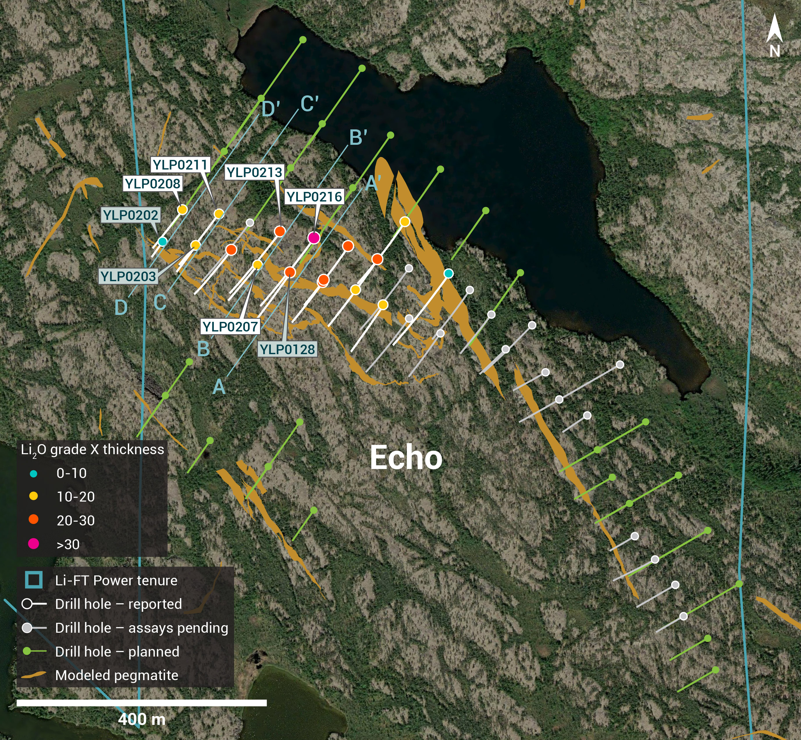
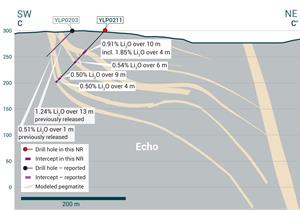
Figure 2 – Plan view showing the surface expression of the Echo pegmatite with diamond drill holes reported in this press release.
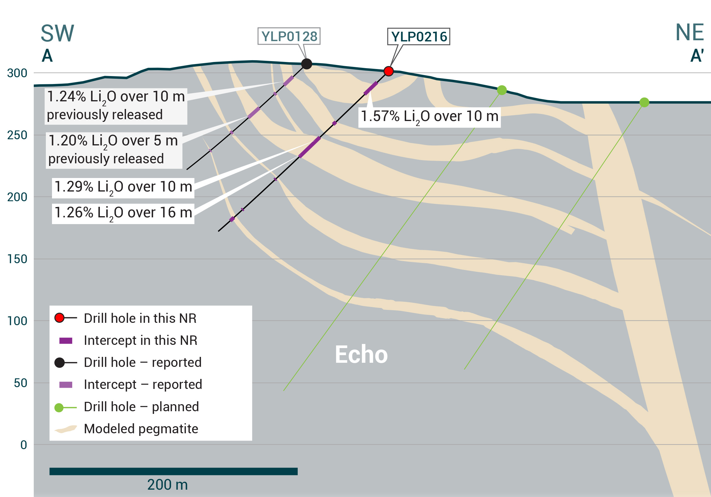
Figure 3 – Cross-section illustrating YLP-0216 with results as shown in the Echo pegmatite dyke with a 16 m interval of 1.26% Li2O.
YLP-0207 tested the Echo splay on a section 50 m northwest of YLP-0216, approximately 450 m northwest of the Echo feeder, 200 m from its northwestern mapped extent, 25-50 m below the surface, and 100 m up-dip from YLP-0213 (see below). Drilling intersected a 65 m wide interval with 25 m of pegmatite spread over three dykes that are between 6-12 m wide. Assays returned composites of 0.95% Li2O over 10 m from the upper-most dyke, which includes 5 m of 1.47% Li2O, as well as 0.79% Li2O over 1 m from the second dyke.
YLP-0213 tested the same section as YLP-207 but with intersections targeted 50 m further downdip to 75-100 m below the surface. Drilling intersected two dyke corridors separated by 55 m of country rock. The upper corridor is 66 m wide with 30 m of pegmatite spread over a 16 m wide dyke and five subsidiary dykes between 1-6 m in width. The lower corridor comprises a single dyke that is 23 m wide. Assays returned 1.20% Li2O over 14 m from the thick dyke in the upper corridor along with 0.59% Li2O over 1 m from one of the subsidiary dykes. The lower corridor returned a composite of 0.73% Li2O over 15 m that includes 2 m of 1.43% Li2O (Table 1 & 2, Figures 2 & 4).
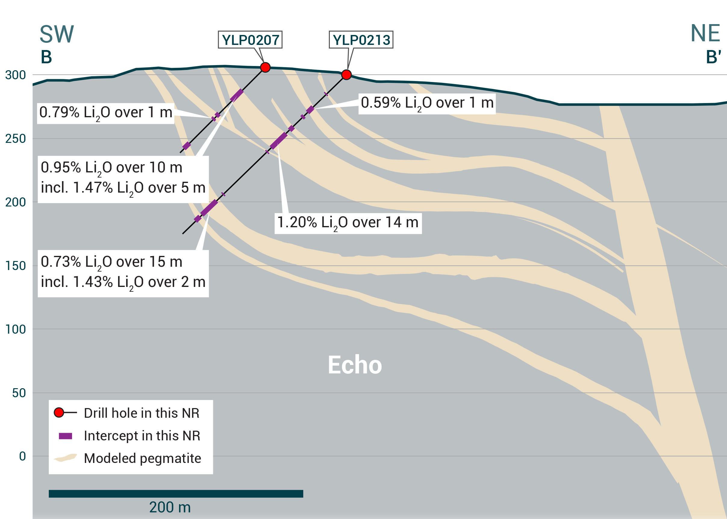
Figure 4 – Cross-section illustrating YLP-0213 with results as shown in the Echo pegmatite dyke with a 14 m interval of 1.20% Li2O.
YLP-0211 was collared 100 m northwest of YLP-0213 to test the Echo splay approximately 550 m from the feeder dyke, 100 m from its northwest extent, 50-100 m below the surface, and 50 m downdip of YLP-0203 (1.24% Li2O over 13 m). Drilling intersected two intervals of increased pegmatite; an upper one that is 35 m wide with 20 m of pegmatite spread over three dykes between 4-10 m in width as well as a lower one that is 17 m wide and contains 13 m of pegmatite. Assays for the upper interval returned 0.91% Li2O over 10 m and 0.54% Li2O over 6 m, the former including 4 m of 1.85% Li2O. The lower interval returned composites of 0.50% Li2O over 9 m and 0.50% Li2O over 4 m (Table 1 & 2, Figures 2 & 5).
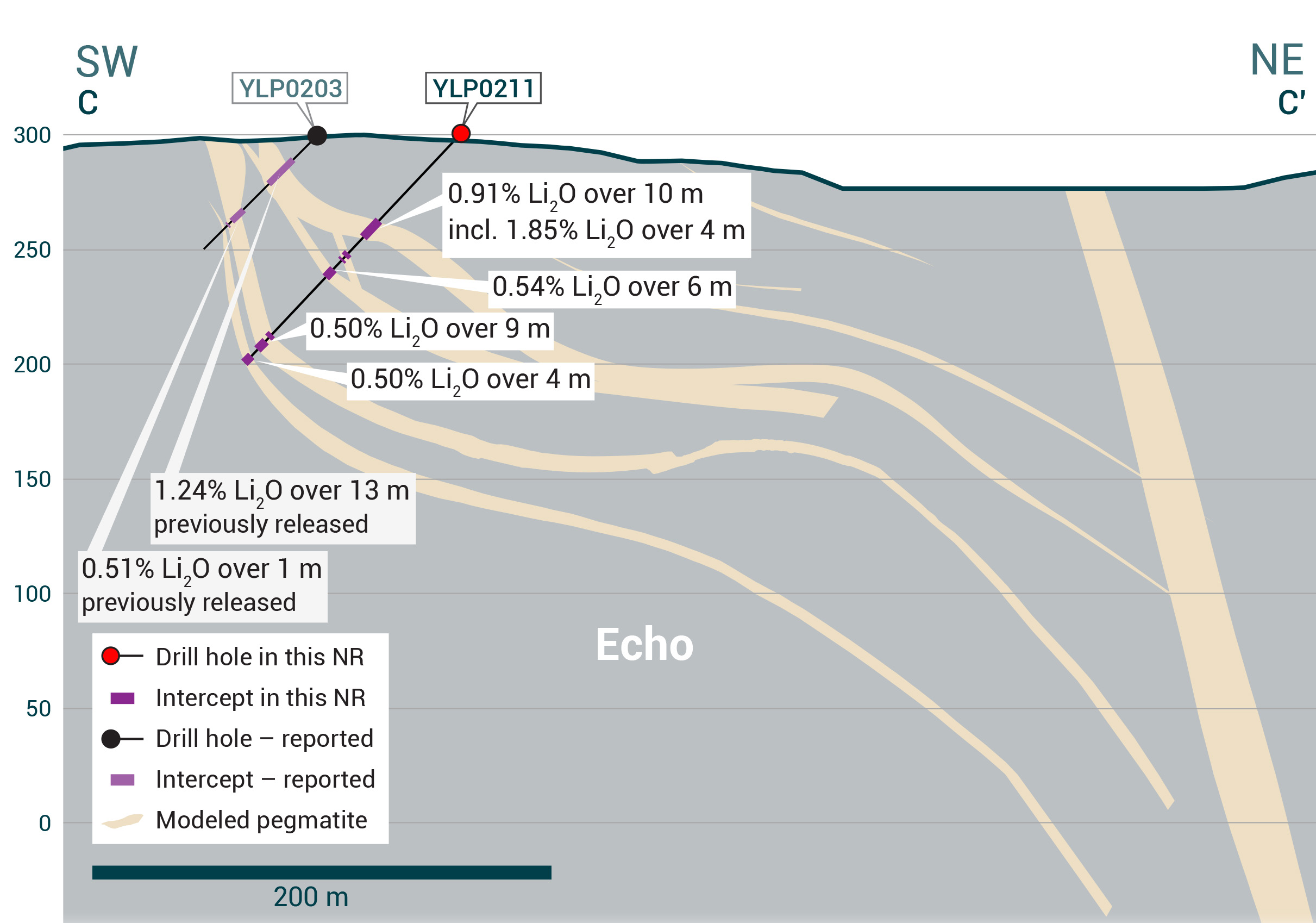
Figure 5: – Cross-section illustrating YLP-0208 with results as shown in the Echo pegmatite dyke with a 10 m interval of 0.95% Li2O.
YLP-0208 tested the tip of the Echo splay just 50 m from its northwest mapped extent, 600 m from the feeder dyke, 50-100 m below the surface, and 50 m downdip of YLP-0202 (0.90% Li2O over 3 m and 0.50% Li2O over 7 m). Drilling intersected a 58 m wide interval with 32 m of pegmatite spread over four dykes between 3-12 m in width. Assay composites for the upper-most dyke returned 0.95% Li2O over 10 m that includes 6 m at 1.38% Li2O whereas the lower-most dyke returned 1.00% Li2O over 3 m (Table 1 & 2, Figures 2 & 6).
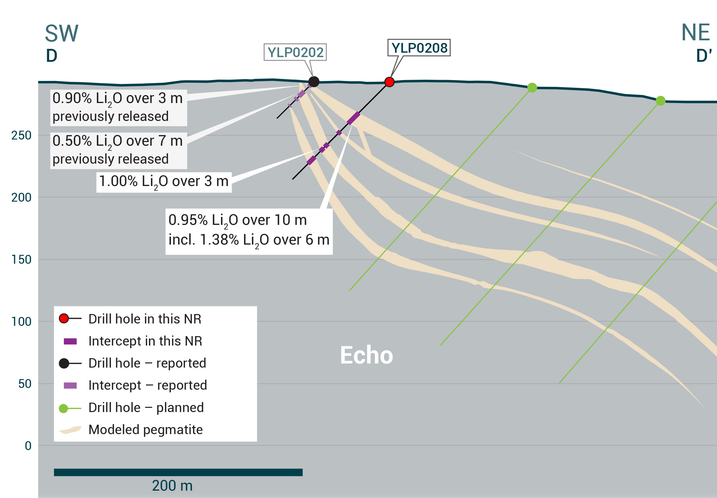
Figure 6: – Cross-section illustrating YLP-0211 with results as shown in the Echo pegmatite dyke with a 10 m interval of 0.91% Li2O.
Fi Main Pegmatite
The
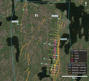
YLP-0190 tested the Fi Main complex approximately 200 m north of the historically mapped northern end extent of the complex and 400 m north of the 2nd most northerly hole (YLP-0024) that returned 1.12% Li2O over 24 m. Drilling intersected a 126 m wide corridor with 31 m of pegmatite split among two 11 m wide dykes as well as five 1-3 m wide dykes. No significant assay results were returned (Table 1 & 2, Figure 7).
Fi Boye Pegmatite
The
YLP-0186 was drilled to test the Fi Boye dyke approximately 500 m from its northern mapped extent and 100 m beneath the surface. Drilling intersected a 25 m wide corridor with 21 m of pegmatite that returned negligible assay results (Table 1 & 2, Figure 7).
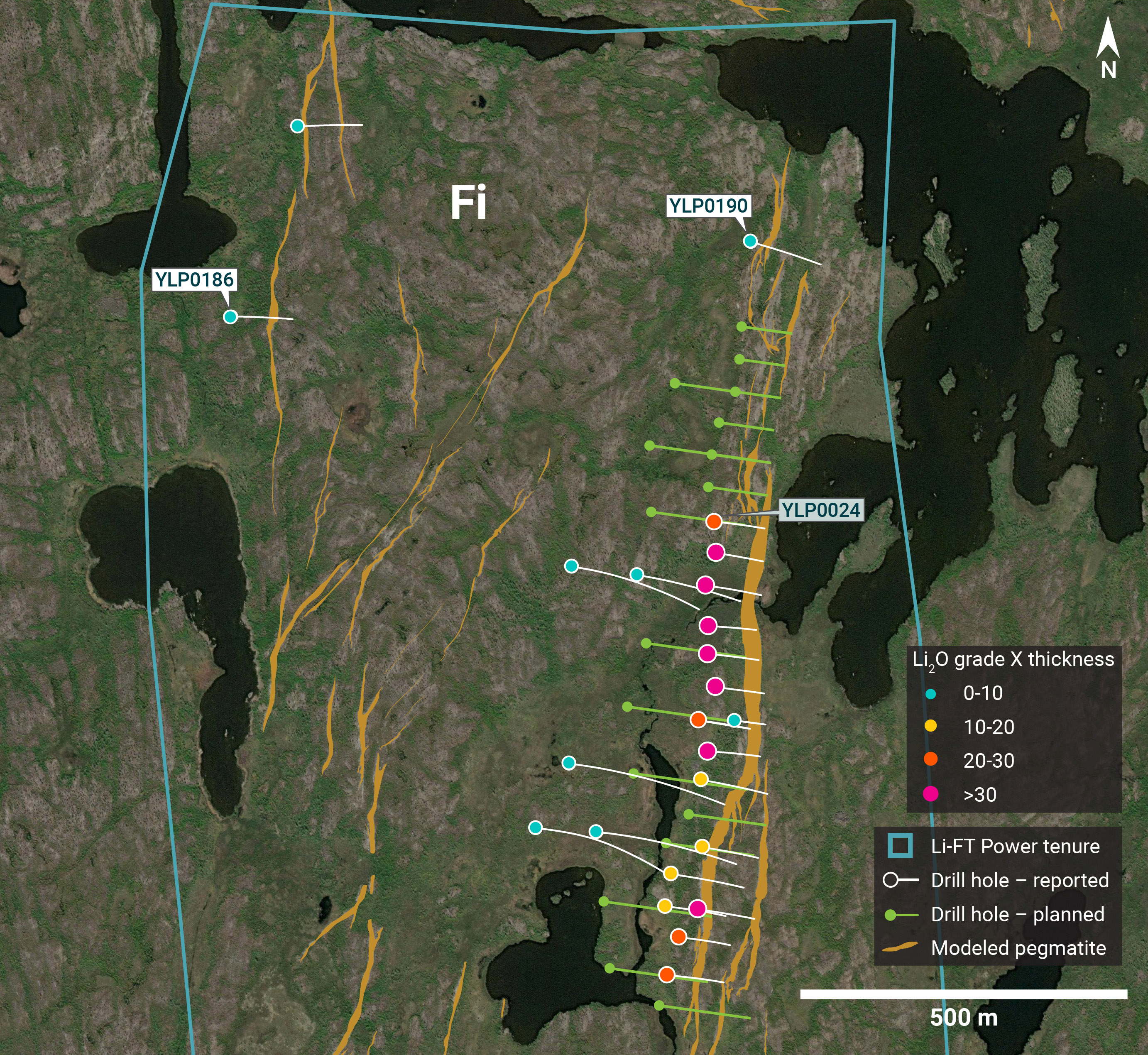
Figure 7 – Plan view showing the surface expression of the Fi Main and
Fi Southwest Pegmatite
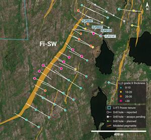
The Fi SW dyke strikes over at least 1.1 km on surface with an average outcropping width of approximately 20 m. The dyke dips between 60°- 80° to the east-southeast and trends towards the north-northeast. Drilling of Fi SW show that it ranges from a single 20-40 m wide dyke to 2-3 dykes of similar cumulative width within a 50-70 m wide corridor.
YLP-0187 tested the Fi SW pegmatite approximately 150 m from its northern mapped extent and 250 m vertically below the surface, as well as 50 m, 125 m, and 200 m downdip of, respectively, previously released intersections that ranged between 1.2-1.5% Li2O over 12-23 m (YLP-0031, 0047, 0125). Drilling intersected a 20 m wide pegmatite dyke that returned negligible grade (Table 1 & 2, Figure 8).
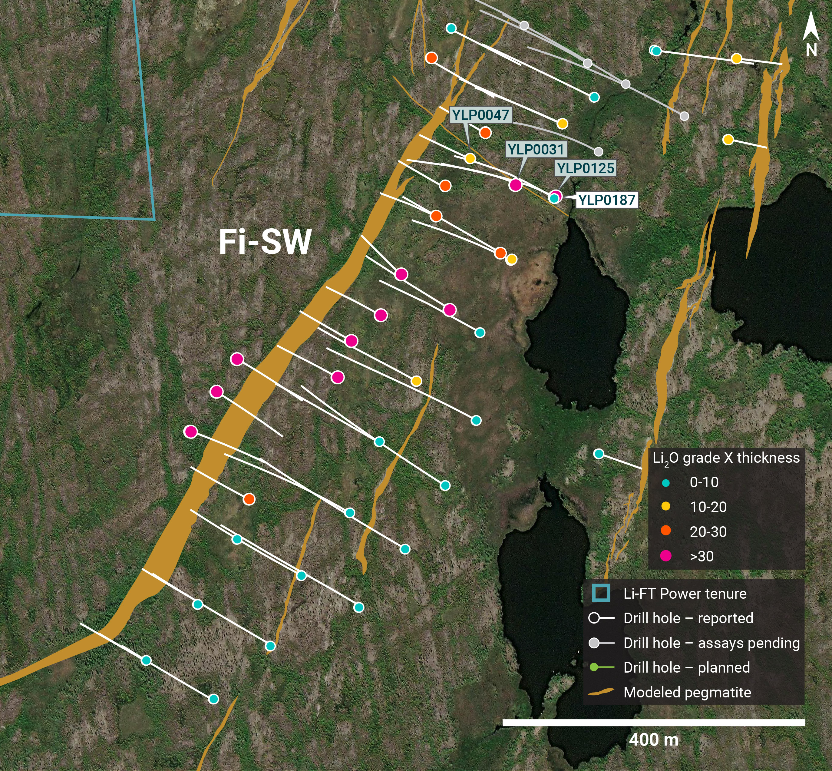
Figure 8 – Plan view showing the surface expression of the Fi Southwest pegmatite with diamond drill holes reported in this press release.
Table 1 – Assay highlights for drill holes reported in this press release.
| Hole No. | From (m) | To (m) | Interval (m) | Li2O% | Dyke |
| YLP-0186 | No significant results | ||||
| YLP-0187 | No significant results | Fi SW | |||
| YLP-0190 | No significant results | ||||
| YLP-0207 | 27 | 37 | 10 | 0.95 | Echo |
| inc | 30 | 35 | 5 | 1.47 | |
| and | 52 | 53 | 1 | 0.79 | |
| YLP-0208 | 37 | 47 | 10 | 0.95 | Echo |
| inc | 38 | 44 | 6 | 1.38 | |
| and | 86 | 89 | 3 | 1.00 | |
| YLP-0211 | 50 | 60 | 10 | 0.91 | Echo |
| inc | 53 | 57 | 4 | 1.85 | |
| and | 79 | 85 | 6 | 0.54 | |
| and | 118 | 127 | 9 | 0.50 | |
| and | 131 | 135 | 4 | 0.50 | |
| YLP-0213 | 37 | 38 | 1 | 0.59 | Echo |
| and | 68 | 82 | 14 | 1.20 | |
| and | 149 | 164 | 15 | 0.73 | |
| inc | 162 | 164 | 2 | 1.43 | |
| YLP-0216 | 15 | 25 | 10 | 1.57 | Echo |
| and | 62 | 72 | 10 | 1.29 | |
| and | 77 | 93 | 16 | 1.26 | |
General Statements
All eight holes described in this news release were drilled broadly perpendicular to the dyke orientation so that the true thickness of reported intercepts will range somewhere between 65-100% of the drilled widths. A collar header table is provided below.
Mineralogical characterization for the YLP- pegmatites is in progress through hyperspectral core scanning and X-ray diffraction work. Visual core logging indicates that the predominant host mineral is spodumene.
Table 2 - Drill collars table of reported drill holes in this press release
| Drill Hole | NAD83 | Easting | Northing | Elevation (m) | Azimuth (°) | Dip (°) | Depth (m) | Dyke |
| YLP-0186 | Zone 12 | 371,056 | 6,942,338 | 253 | 93 | 46 | 138 | |
| YLP-0187 | Zone 12 | 371,554 | 6,940,936 | 251 | 302 | 70 | 396 | Fi SW |
| YLP-0190 | Zone 12 | 371,850 | 6,942,452 | 255 | 108 | 45 | 159 | |
| YLP-0207 | Zone 12 | 439,057 | 6,922,657 | 307 | 215 | 45 | 105 | Echo |
| YLP-0208 | Zone 12 | 438,937 | 6,922,745 | 295 | 215 | 45 | 111 | Echo |
| YLP-0211 | Zone 12 | 438,994 | 6,922,739 | 301 | 215 | 48 | 150 | Echo |
| YLP-0213 | Zone 12 | 439,094 | 6,922,711 | 304 | 215 | 45 | 180 | Echo |
| YLP-0216 | Zone 12 | 439,146 | 6,922,698 | 303 | 215 | 45 | 189 | Echo |
QA/QC & Core Sampling Protocols
All drill core samples were collected under the supervision of LIFT employees and contractors. Drill core was transported from the drill platform to the core processing facility where it was logged, photographed, and split by diamond saw prior to being sampled. Samples were then bagged, and blanks and certified reference materials were inserted at regular intervals. Field duplicates consisting of quarter-cut core samples were also included in the sample runs. Groups of samples were placed in large bags, sealed with numbered tags in order to maintain a chain-of-custody, and transported from LIFT’s core logging facility to
Sample preparation and analytical work for this drill program were carried out by ALS. Samples were prepared for analysis according to ALS method CRU31: individual samples were crushed to 70% passing through 2 mm (10 mesh) screen; a 1,000-gram sub-sample was riffle split (SPL-21) and then pulverized (PUL-32) such that 85% passed through 75 micron (200 mesh) screen. A 0.2-gram sub-sample of the pulverized material was then dissolved in a sodium peroxide solution and analysed for lithium according to ALS method ME-ICP82b. Another 0.2-gram sub-sample of the pulverized material was analysed for 53 elements according to ALS method ME-MS89L. All results passed the QA/QC screening at the lab, all inserted standards and blanks returned results that were within acceptable limits.
Qualified Person
The disclosure in this news release of scientific and technical information regarding LIFT’s mineral properties has been reviewed and approved by
About LIFT
LIFT is a mineral exploration company engaged in the acquisition, exploration, and development of lithium pegmatite projects located in
| For further information, please contact: | ||
Chief Executive Officer Tel: + 1.604.609.6185 Email: info@li-ft.com Website: www.li-ft.com | Investor Relations Tel: +1.604.609.6185 Email: investors@li-ft.com | |
Cautionary Statement Regarding Forward-Looking Information
Certain statements included in this press release constitute forward-looking information or statements (collectively, “forward-looking statements”), including those identified by the expressions “anticipate”, “believe”, “plan”, “estimate”, “expect”, “intend”, “may”, “should” and similar expressions to the extent they relate to the Company or its management. The forward-looking statements are not historical facts but reflect current expectations regarding future results or events. This press release contains forward looking statements. These forward-looking statements and information reflect management's current beliefs and are based on assumptions made by and information currently available to the company with respect to the matter described in this new release.
Forward-looking statements involve risks and uncertainties, which are based on current expectations as of the date of this release and subject to known and unknown risks and uncertainties that could cause actual results to differ materially from those expressed or implied by such statements. Additional information about these assumptions and risks and uncertainties is contained under "Risk Factors and Uncertainties" in the Company's latest annual information form filed on
Neither the


Figure 1
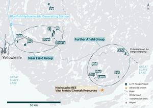
Location of LIFT’s Yellowknife Lithium Project . Drilling has been thus far focused on the Near Field Group of pegmatites which are located to the east of the city of Yellowknife along a government-maintained paved highway, as well as the Echo target in the Further Afield Group .
Figure 2
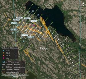
Plan view showing the surface expression of the Echo pegmatite with diamond drill holes reported in this press release.
Figure 3
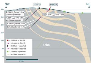
Cross-section illustrating YLP-0216 with results as shown in the Echo pegmatite dyke with a 16 m interval of 1.26% Li2O.
Figure 4
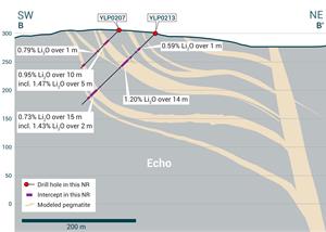
Cross-section illustrating YLP-0213 with results as shown in the Echo pegmatite dyke with a 14 m interval of 1.20% Li2O.
Figure 5
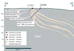
Cross-section illustrating YLP-0208 with results as shown in the Echo pegmatite dyke with a 10 m interval of 0.95% Li2O.
Figure 6
Cross-section illustrating YLP-0211 with results as shown in the Echo pegmatite dyke with a 10 m interval of 0.91% Li2O.
Figure 7
Plan view showing the surface expression of the Fi Main and Fi Boye pegmatites with diamond drill holes reported in this press release.
Figure 8
Plan view showing the surface expression of the Fi Southwest pegmatite with diamond drill holes reported in this press release.
2024 GlobeNewswire, Inc., source

